चित्र:Caucasus region 1994.jpg

ए नमूना के साइज: 782 × 600 पिक्सेल. अउरी रिजोल्यूशन: 313 × 240 पिक्सेल | 626 × 480 पिक्सेल | 1,002 × 768 पिक्सेल | 1,280 × 982 पिक्सेल | 2,560 × 1,963 पिक्सेल | 3,119 × 2,392 पिक्सेल.
ओरिजनल फाइल (3,119 × 2,392 पिक्सेल, फाइल साइज: 1.18 MB, MIME टाइप: image/jpeg)
| बिबरण |
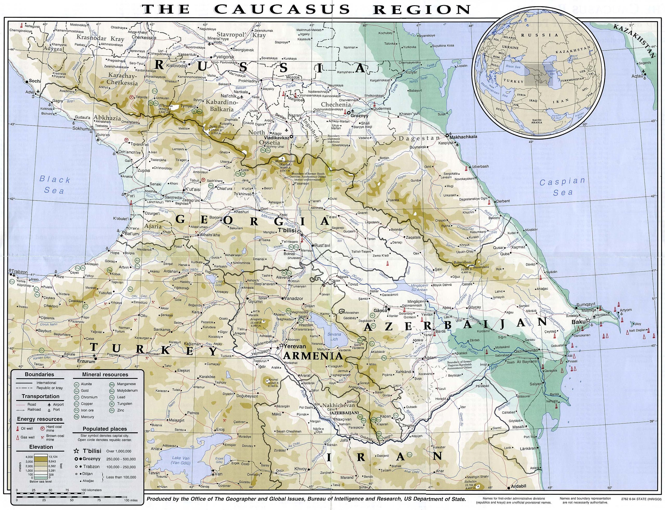
English: Map of the Caucasus region in 1994
Français : Carte du Caucase en 1994 |
|||
| तारीख | ||||
| स्रोत | University of Texas Library | |||
| लेखक | CIA | |||
| परमीशन (एह फाइल के दुबारा इस्तेमाल) |
|
|||
| Other versions |


फाइल के इतिहास
ओ समय ई फाइल कइसन लउके ई देखे खातिर कौनों तारीख/समय पर क्लिक करीं।
| तारीख/समय | चिप्पी रूप | डाइमेंशन | प्रयोगकर्ता | टिप्पणी | |
|---|---|---|---|---|---|
| वर्तमान | 14:49, 16 जुलाई 2007 | | 3,119 × 2,392 (1.18 MB) | Pmx | {{Information |Description= {{en|Map of the Caucasus region in 1994}} {{fr|Carte du Caucase en 1994}} |Source=University of Texas Library [http://www.lib.utexas.edu/maps/commonwealth/caucasus_region_1994.jpg] |Date=1994 |Author=CIA |Permission=Public doma |
फाइल के उपयोग
फाइल के इस्तेमाल पन्ना करत बा:
बैस्विक फाइल उपयोग
नीचे दिहल अउरी विकिसभ पर एह फाइल के इस्तेमाल हो रहल बा:
- ar.wikipedia.org पर इस्तेमाल
- arz.wikipedia.org पर इस्तेमाल
- ast.wikipedia.org पर इस्तेमाल
- azb.wikipedia.org पर इस्तेमाल
- az.wikipedia.org पर इस्तेमाल
- ba.wikipedia.org पर इस्तेमाल
- bg.wikipedia.org पर इस्तेमाल
- bs.wikipedia.org पर इस्तेमाल
- ca.wikipedia.org पर इस्तेमाल
- de.wikivoyage.org पर इस्तेमाल
- en.wikipedia.org पर इस्तेमाल
- eo.wikipedia.org पर इस्तेमाल
- eu.wikipedia.org पर इस्तेमाल
- fr.wikipedia.org पर इस्तेमाल
- ga.wikipedia.org पर इस्तेमाल
- he.wikipedia.org पर इस्तेमाल
- hif.wikipedia.org पर इस्तेमाल
- hr.wikipedia.org पर इस्तेमाल
- hu.wikipedia.org पर इस्तेमाल
- id.wikipedia.org पर इस्तेमाल
- it.wikipedia.org पर इस्तेमाल
- it.wikivoyage.org पर इस्तेमाल
- kk.wikipedia.org पर इस्तेमाल
- ko.wikipedia.org पर इस्तेमाल
- ku.wikipedia.org पर इस्तेमाल
- ml.wikipedia.org पर इस्तेमाल
- ms.wikipedia.org पर इस्तेमाल
- pnb.wikipedia.org पर इस्तेमाल
- pt.wikipedia.org पर इस्तेमाल
- ro.wikipedia.org पर इस्तेमाल
- sl.wikipedia.org पर इस्तेमाल
- so.wikipedia.org पर इस्तेमाल
- su.wikipedia.org पर इस्तेमाल
- sv.wikivoyage.org पर इस्तेमाल
- ta.wikipedia.org पर इस्तेमाल
- tg.wikipedia.org पर इस्तेमाल
- th.wikipedia.org पर इस्तेमाल
- tl.wikipedia.org पर इस्तेमाल
एह फाइल के अउरी बैस्विक इस्तेमाल देखीं