चित्र:Ecuadores.png

ओरिजनल फाइल (2,753 × 1,335 पिक्सेल, फाइल साइज: 233 KB, MIME टाइप: image/png)
सारांश
| बिबरण |
English: World map of climate equators Español: Mapamundi de los ecuadores climáticos |
| तारीख | |
| स्रोत | आपन रचना |
| लेखक | Maulucioni |
English
Español
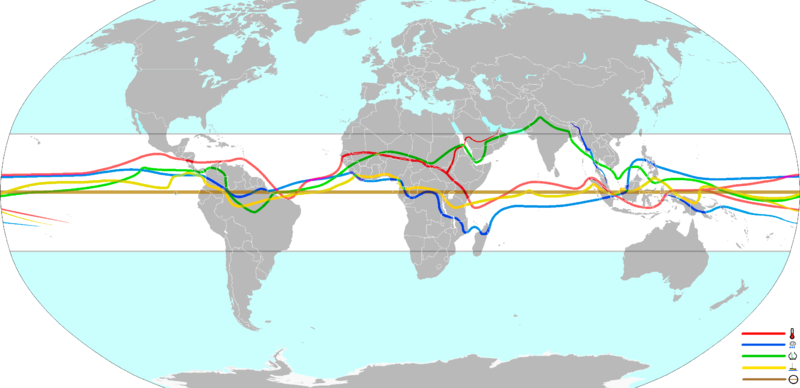
Ecuador térmico o ecuador cálido, determinado por la media anual continua de máximas temperaturas de acuerdo al mapa atmosférico continental,[1] del suelo,[2] de la superficie marítima[3] y mapas globales.[4][5]
Cinturón lluvioso o ecuador pluvial, determinado por la media anual continua de máximas precipitaciones dentro del cinturón de lluvias tropicales de acuerdo a mapas continentales[6][7] y globales.[8][9]
Vaguada ecuatorial o ecuador meteorológico, determinado por los valores medios anuales del cinturón tropical de baja presión atmosférica,[10] [11] [12] el cual se relaciona con la zona de convergencia intertropical.
Calma ecuatorial, determinada por la media anual continua de la menor velocidad de los vientos de acuerdo con mapas continentales[13] y globales.[14]
Es común la formación de doble ecuador climático en varias tierras y océanos según la temporada. En este mapa se muestra la principal duplicidad, la cual es propia del Pacífico occidental y que implica formación de doble banda térmica, de nubes, de calma y de convergancia:[15] [16] la ZCIT y la ZCPS (zona de convergencia del Pacifico sur).
References
- ↑ Temperature maps archive copy at the Wayback Machine 1989-2009 en Solargis.info
- ↑ Soil Temperature Regimes USDA 2015
- ↑ Annual mean sea surface temperature World Ocean Atlas 2005
- ↑ The global mean annual temperature (MAT) 1961-1990. University of East Anglia
- ↑ Global map of the annually-averaged near-surface air temperature Robert A. Rohde 2008 for Global Warming Art (Commons)
- ↑ Mean Annual Precipitation 1961-1990 whymap.org
- ↑ Annual precipitation throughout the world Commons 2007
- ↑ Global Ocean Currents Explain Why Northern Hemisphere Is the Soggier One University of Washington. Oceanleadership.org 2013
- ↑ Global distribution of precipitation 1980-2004 Encyclopedia of Earth 2006
- ↑ Robert H. Stewart 2005 Atmospheric Influences. archive copy at the Wayback Machine Texas A&M University
- ↑ Annual Mean Sea Level Pressure: 1979 - 1995 NOAA/ National Weather Service 2002
- ↑ Sea level pressure 2007-2008 Alaska Sea Grant 2015
- ↑ Global Mean Wind Speed at 80m 3tier.com
- ↑ NASA 2014 Surface meteorology and Solar Energy (SSE) archive copy at the Wayback Machine File:Global Annual 10m Average Wind Speed.png, File:Global Annual 50m Average Wind Speed.png 1983-1993
- ↑ John E. Oliver. The Encyclopedia of World Climatology. Double ITCZ
- ↑ Yen-Ting Hwang and Dargan Frierson 2012. Link between the double-Intertropical Convergence Zone problem and cloud biases over the Southern Ocean Current Issue vol.110 nº.13 4935–4940, doi: 10.1073/pnas.1213302110
लाइसेंसिंग
- आप फ्री बानी:
- साझा करे खातिर – रचना के नकल करे, बाँटे आ दुसरी जगह भेजे खातिर
- रीमिक्स करे खातिर – काम के अपनी हिसाब से बनावे खातिर
- नीचे दिहल कारणन की तहत:
- एट्रीब्यूशन – लाइसेंस के कड़ी दे के उचित श्रेय (क्रेडिट) दिहल जरूरी बा आ अगर कौनों बदलाव कइल गइल बा तब ओहू के बतावल जाए के चाहीं। आप ई काम कौनों उचित तरीका से क सकत बानी, बाकी ई न झलके के चाहीं की जेकरा लगे लाइसेंस बा ऊ राउर चाहे राउर काम के समर्थन करत बाटे या सही बतावत बा।
- शेयर अलाइक (share alike) – अगर आप एह सामग्री के आधार बना के कुछ रिमिक्स करत बानी, रूप बदलाव करत बानी, चाहे कुछ जोड़ के सामग्री के बढ़ावत बानी, आपके आपन योगदान ठीक एही या कंपेटिबल लाइसेंस जइसन कि ओरिजनल बाटे, के तहत होखे के चाहीं।
फाइल के इतिहास
ओ समय ई फाइल कइसन लउके ई देखे खातिर कौनों तारीख/समय पर क्लिक करीं।
| तारीख/समय | चिप्पी रूप | डाइमेंशन | प्रयोगकर्ता | टिप्पणी | |
|---|---|---|---|---|---|
| वर्तमान | 18:02, 10 अप्रैल 2015 | | 2,753 × 1,335 (233 KB) | Maulucioni | adding trough |
| 16:20, 15 मार्च 2015 |  | 2,753 × 1,335 (147 KB) | Maulucioni | User created page with UploadWizard |
फाइल के उपयोग
फाइल के इस्तेमाल पन्ना करत बा:
बैस्विक फाइल उपयोग
नीचे दिहल अउरी विकिसभ पर एह फाइल के इस्तेमाल हो रहल बा:
- ar.wikipedia.org पर इस्तेमाल
- es.wikipedia.org पर इस्तेमाल
- www.wikidata.org पर इस्तेमाल