चित्र:Elevation.jpg

ए नमूना के साइज: 800 × 400 पिक्सेल. अउरी रिजोल्यूशन: 320 × 160 पिक्सेल | 640 × 320 पिक्सेल | 1,024 × 512 पिक्सेल | 1,280 × 640 पिक्सेल | 2,560 × 1,280 पिक्सेल | 10,800 × 5,400 पिक्सेल.
ओरिजनल फाइल (10,800 × 5,400 पिक्सेल, फाइल साइज: 25.61 MB, MIME टाइप: image/jpeg)
सारांश
| बिबरण |
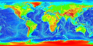
English: Global land and undersea elevation. (flat projection
Deutsch: Globales Höhenprofil (Flachkarte) |
| तारीख | Unknown date |
| स्रोत | http://www.ngdc.noaa.gov/mgg/image/2minrelief.html |
| लेखक | National Oceanic and Atmospheric Administration |
To calculate geografic coordinates to map coordinates: X = (180 + longitude) * width of map / 360 // west is minus Y = (90 + latitude) * height of map / 360 // north is minus
लाइसेंसिंग
This image is in the public domain because it contains materials that originally came from the U.S. National Oceanic and Atmospheric Administration, taken or made as part of an employee's official duties.
|
![]()
See also
- Image:LARGE elevation.jpg — a high-resolution (13MB) version of this image
- Image:Earth surface NGDC 2000.jpg — made from similar data
फाइल के इतिहास
ओ समय ई फाइल कइसन लउके ई देखे खातिर कौनों तारीख/समय पर क्लिक करीं।
| तारीख/समय | चिप्पी रूप | डाइमेंशन | प्रयोगकर्ता | टिप्पणी | |
|---|---|---|---|---|---|
| वर्तमान | 20:02, 19 अगस्त 2023 | | 10,800 × 5,400 (25.61 MB) | Kersti Nebelsiek | higher resolution |
| 23:11, 13 नवंबर 2021 |  | 5,400 × 2,700 (14.08 MB) | Antonsusi | resolution | |
| 01:59, 7 मार्च 2006 |  | 4,320 × 2,160 (1.86 MB) | Interiot~commonswiki | Global land and undersea elevation. Source: http://www.ngdc.noaa.gov/mgg/image/2minrelief.html |
फाइल के उपयोग
फाइल के इस्तेमाल पन्ना करत बा:
बैस्विक फाइल उपयोग
नीचे दिहल अउरी विकिसभ पर एह फाइल के इस्तेमाल हो रहल बा:
- af.wikipedia.org पर इस्तेमाल
- an.wikipedia.org पर इस्तेमाल
- ar.wikipedia.org पर इस्तेमाल
- ast.wikipedia.org पर इस्तेमाल
- awa.wikipedia.org पर इस्तेमाल
- az.wikipedia.org पर इस्तेमाल
- ba.wikipedia.org पर इस्तेमाल
- be-tarask.wikipedia.org पर इस्तेमाल
- be.wikipedia.org पर इस्तेमाल
- bg.wikipedia.org पर इस्तेमाल
- br.wikipedia.org पर इस्तेमाल
- bs.wikipedia.org पर इस्तेमाल
- ca.wikipedia.org पर इस्तेमाल
- ce.wikipedia.org पर इस्तेमाल
- ckb.wikipedia.org पर इस्तेमाल
- cs.wikipedia.org पर इस्तेमाल
- da.wikipedia.org पर इस्तेमाल
- de.wikipedia.org पर इस्तेमाल
- el.wikipedia.org पर इस्तेमाल
- en.wikipedia.org पर इस्तेमाल
- en.wikiversity.org पर इस्तेमाल
- eo.wikipedia.org पर इस्तेमाल
- es.wikipedia.org पर इस्तेमाल
- et.wikipedia.org पर इस्तेमाल
- eu.wikipedia.org पर इस्तेमाल
- fa.wikipedia.org पर इस्तेमाल
- fi.wikipedia.org पर इस्तेमाल
- fr.wikipedia.org पर इस्तेमाल
- ga.wikipedia.org पर इस्तेमाल
- gl.wikipedia.org पर इस्तेमाल
एह फाइल के अउरी बैस्विक इस्तेमाल देखीं