चित्र:Ethiopia central lakes.jpg
ए से उच्च गुणवत्ता उपलब्ध नइखे।
Ethiopia_central_lakes.jpg (171 × 185 पिक्सेल, फाइल साइज: 48 KB, MIME टाइप: image/jpeg)
सारांश
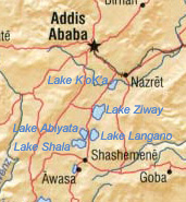
| बिबरण | Rift Valley lakes in Ethiopia |
| तारीख | |
| स्रोत | File:Ethiopia shaded relief map 1999, CIA.jpg |
| लेखक | CIA, derivative work: Dmcdevit |
लाइसेंसिंग
| This image is a work of a Central Intelligence Agency employee, taken or made as part of that person's official duties. As a Work of the United States Government, this image or media is in the public domain in the United States.
|

|
Original upload log
- 04:08, 28 July 2007 || w:en:User:Badagnani || 171×185 || 48 KB || Map showing location of lakes in central Ethiopia. Cropped version of http://upload.wikimedia.org/wikipedia/commons/9/97/Ethiopia_Map.jpg {{PD-USGov-CIA}}
फाइल के इतिहास
ओ समय ई फाइल कइसन लउके ई देखे खातिर कौनों तारीख/समय पर क्लिक करीं।
| तारीख/समय | चिप्पी रूप | डाइमेंशन | प्रयोगकर्ता | टिप्पणी | |
|---|---|---|---|---|---|
| वर्तमान | 04:52, 8 सितंबर 2007 | | 171 × 185 (48 KB) | BetacommandBot | Transwiki approved by: w:en:User:Dmcdevit This image was copied from wikipedia:en. The original description was: Map showing location of lakes in central Ethiopia. Cropped version of http://upload.wikimedia.org/wikipedia/commons/9/97/Ethiopia_Map.jp |
फाइल के उपयोग
फाइल के इस्तेमाल पन्ना करत बा:
बैस्विक फाइल उपयोग
नीचे दिहल अउरी विकिसभ पर एह फाइल के इस्तेमाल हो रहल बा:
- da.wikipedia.org पर इस्तेमाल
- de.wikivoyage.org पर इस्तेमाल
- en.wikipedia.org पर इस्तेमाल
- en.wikivoyage.org पर इस्तेमाल
- eo.wikipedia.org पर इस्तेमाल
- es.wikipedia.org पर इस्तेमाल
- et.wikipedia.org पर इस्तेमाल
- fa.wikipedia.org पर इस्तेमाल
- fi.wikipedia.org पर इस्तेमाल
- fr.wikipedia.org पर इस्तेमाल
- id.wikipedia.org पर इस्तेमाल
- ka.wikipedia.org पर इस्तेमाल
- mk.wikipedia.org पर इस्तेमाल
- mn.wikipedia.org पर इस्तेमाल
- my.wikipedia.org पर इस्तेमाल
- nl.wikipedia.org पर इस्तेमाल
- nn.wikipedia.org पर इस्तेमाल
- ro.wikipedia.org पर इस्तेमाल
- sw.wikipedia.org पर इस्तेमाल
- www.wikidata.org पर इस्तेमाल
- zh.wikipedia.org पर इस्तेमाल