चित्र:Geikie Plateau Glacier.JPG

ए नमूना के साइज: 800 × 600 पिक्सेल. अउरी रिजोल्यूशन: 320 × 240 पिक्सेल | 640 × 480 पिक्सेल | 1,024 × 768 पिक्सेल.
ओरिजनल फाइल (1,024 × 768 पिक्सेल, फाइल साइज: 284 KB, MIME टाइप: image/jpeg)
सारांश
| बिबरण |
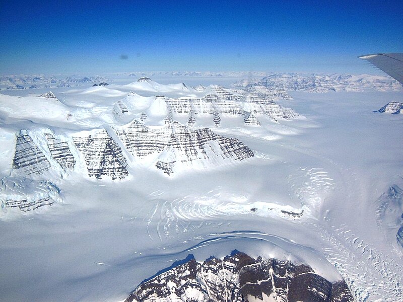
English: Geikie Plateau glacier and mountain peaks in eastern Greenland seen from NASA's P-3B during an IceBridge survey flight on Apr. 11, 2013. The distinctive layering in the Geikie Plateau's mountains come from repeated flooding of basalt lava from the North Atlantic's mid-ocean ridge millions of years ago. |
| तारीख | |
| स्रोत | http://www.nasa.gov/mission_pages/icebridge/multimedia/spr13/DSCN3043.html |
| लेखक | NASA / Christy Hansen |
लाइसेंसिंग
| This file is in the public domain in the United States because it was solely created by NASA. NASA copyright policy states that "NASA material is not protected by copyright unless noted". (See Template:PD-USGov, NASA copyright policy page or JPL Image Use Policy.) | ||
 |
Warnings:
|
फाइल के इतिहास
ओ समय ई फाइल कइसन लउके ई देखे खातिर कौनों तारीख/समय पर क्लिक करीं।
| तारीख/समय | चिप्पी रूप | डाइमेंशन | प्रयोगकर्ता | टिप्पणी | |
|---|---|---|---|---|---|
| वर्तमान | 08:35, 27 अप्रैल 2013 | | 1,024 × 768 (284 KB) | Stas1995 | User created page with UploadWizard |
फाइल के उपयोग
फाइल के इस्तेमाल पन्ना करत बा:
बैस्विक फाइल उपयोग
नीचे दिहल अउरी विकिसभ पर एह फाइल के इस्तेमाल हो रहल बा:
- blk.wikipedia.org पर इस्तेमाल
- en.wikipedia.org पर इस्तेमाल
- en.wikibooks.org पर इस्तेमाल
- kk.wikipedia.org पर इस्तेमाल
- la.wikipedia.org पर इस्तेमाल
- www.wikidata.org पर इस्तेमाल