चित्र:Hooker Valley Pano MC.jpg

ए नमूना के साइज: 800 × 443 पिक्सेल. अउरी रिजोल्यूशन: 320 × 177 पिक्सेल | 640 × 354 पिक्सेल | 1,024 × 567 पिक्सेल | 1,280 × 709 पिक्सेल | 3,613 × 2,000 पिक्सेल.
ओरिजनल फाइल (3,613 × 2,000 पिक्सेल, फाइल साइज: 5.76 MB, MIME टाइप: image/jpeg)
| Camera location | | View this and other nearby images on: OpenStreetMap |
|---|
| बिबरण |
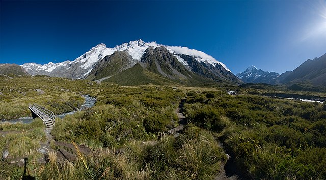
Deutsch: Die Main Divide mit Mt. Sefton und The Footstool, vom Hooker Valley aus gesehen. Rechts im Hintergrund der höchste Berg Neuseelands - Mt. Cook. Panorama zusammengesetzt aus 5 Hochformatbildern. Der Schatten links unten im Bild wurde vom Stativ verursacht, einige Lens Flares wurden in der Nachbearbeitung entfernt.
English: The Main Divide with Mt. Sefton and The Footstool, view from Hooker Valley. On the right side in the background the highest peak in New Zealand - Mt. Cook. Panorama stitched from 5 portrait format images. The shadow on the left bottom is caused by the tripod, some lens flares were removed in post-processing.
Français : Paysage des Alpes du Sud de la Nouvelle-Zélande, depuis la Hooker Valley. Sur la droite et à l'arrière plan on peut voir le Mont Cook, sommet de la Nouvelle-Zélande. Image panoramique obtenue en assemblant cinq images format portrait. |
| तारीख | |
| स्रोत | आपन रचना |
| लेखक | Christian Mehlführer, User:Chmehl |
| परमीशन (एह फाइल के दुबारा इस्तेमाल) |
This file is licensed under the Creative Commons Attribution 2.5 Generic license.
|
| Other versions |
  |
This image has been assessed using the Quality image guidelines and is considered a Quality image.
|
फाइल के इतिहास
ओ समय ई फाइल कइसन लउके ई देखे खातिर कौनों तारीख/समय पर क्लिक करीं।
| तारीख/समय | चिप्पी रूप | डाइमेंशन | प्रयोगकर्ता | टिप्पणी | |
|---|---|---|---|---|---|
| वर्तमान | 19:08, 22 मार्च 2008 | | 3,613 × 2,000 (5.76 MB) | Chmehl | {{Location|43|41|53.2|S|170|5|48.5|E|type:landmark}} {{Information |Description={{de|Die Main Divide mit Mt. Sefton und The Footstool, vom Hooker Valley aus gesehen. Rechts im Hintergrund der höchste Berg Neuseelands - Mt. Cook. Panorama z |
फाइल के उपयोग
फाइल के इस्तेमाल पन्ना करत बा:
बैस्विक फाइल उपयोग
नीचे दिहल अउरी विकिसभ पर एह फाइल के इस्तेमाल हो रहल बा:
- an.wikipedia.org पर इस्तेमाल
- ca.wikipedia.org पर इस्तेमाल
- es.wikipedia.org पर इस्तेमाल
- fr.wikipedia.org पर इस्तेमाल
- hr.wikipedia.org पर इस्तेमाल
- it.wikipedia.org पर इस्तेमाल
- ka.wikipedia.org पर इस्तेमाल
- mg.wikipedia.org पर इस्तेमाल
- mk.wikipedia.org पर इस्तेमाल
- nn.wikipedia.org पर इस्तेमाल
- pnb.wikipedia.org पर इस्तेमाल
- ru.wikipedia.org पर इस्तेमाल
- sh.wikipedia.org पर इस्तेमाल
- sl.wikipedia.org पर इस्तेमाल
- sr.wikipedia.org पर इस्तेमाल
- uk.wikipedia.org पर इस्तेमाल