चित्र:Kansai closeup.jpg
ए से उच्च गुणवत्ता उपलब्ध नइखे।
Kansai_closeup.jpg (800 × 600 पिक्सेल, फाइल साइज: 66 KB, MIME टाइप: image/jpeg)
सारांश
| बिबरण |
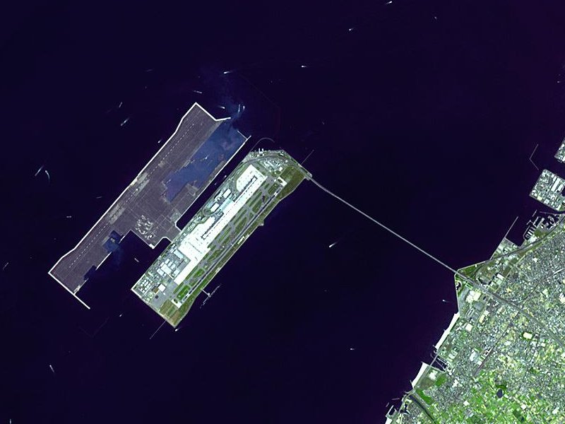
Satellite image of Kansai International Airport in Osaka Bay in Japan. This is a closeup - for an overview image showing the airport on its artificial island in the bay, see Image:Wfm kansai overview.jpg |
| तारीख | |
| स्रोत |
Taken from an uncopyrighted image NASA Earth Observatory |
| लेखक | NASA Earth Observatory |
| परमीशन (एह फाइल के दुबारा इस्तेमाल) |
"The purpose of NASA's Earth Observatory is to provide a freely-accessible publication on the Internet where the public can obtain new satellite imagery and scientific information about our home planet. The focus is on Earth's climate and environmental change. In particular, we hope our site is useful to public media and educators. Any and all materials published on the Earth Observatory are freely available for re-publication or re-use, except where copyright is indicated. We ask that NASA's Earth Observatory be given credit for its original materials." |
| Other versions |

| Object location | | View this and other nearby images on: OpenStreetMap |
|---|
लाइसेंसिंग
| This file is in the public domain in the United States because it was solely created by NASA. NASA copyright policy states that "NASA material is not protected by copyright unless noted". (See Template:PD-USGov, NASA copyright policy page or JPL Image Use Policy.) | ||
 |
Warnings:
|
en.Wikipedia upload log
The en.Wikipedia description page is/was here. All following user names refer to en.Wikipedia.
- 2004-04-05 19:30 Finlay McWalter 800×600 (66 KB) (nasa image of kansai airport)
फाइल के इतिहास
ओ समय ई फाइल कइसन लउके ई देखे खातिर कौनों तारीख/समय पर क्लिक करीं।
| तारीख/समय | चिप्पी रूप | डाइमेंशन | प्रयोगकर्ता | टिप्पणी | |
|---|---|---|---|---|---|
| वर्तमान | 03:46, 13 दिसंबर 2005 | | 800 × 600 (66 KB) | Sam916~commonswiki | Satellite image of Kansai International Airport in Osaka Bay in Japan. This is a closeup - for an overview image showing the airport on its artificial island in the bay, see Image:Wfm kansai overview.jpg Taken from an uncopyrighted imag |
फाइल के उपयोग
फाइल के इस्तेमाल पन्ना करत बा:
बैस्विक फाइल उपयोग
नीचे दिहल अउरी विकिसभ पर एह फाइल के इस्तेमाल हो रहल बा:
- ar.wikipedia.org पर इस्तेमाल
- ast.wikipedia.org पर इस्तेमाल
- bbc.wikipedia.org पर इस्तेमाल
- bg.wikipedia.org पर इस्तेमाल
- bn.wikipedia.org पर इस्तेमाल
- de.wikipedia.org पर इस्तेमाल
- el.wikipedia.org पर इस्तेमाल
- en.wikipedia.org पर इस्तेमाल
- en.wikibooks.org पर इस्तेमाल
- es.wikipedia.org पर इस्तेमाल
- eu.wikipedia.org पर इस्तेमाल
- fa.wikipedia.org पर इस्तेमाल
- fi.wikipedia.org पर इस्तेमाल
- he.wikipedia.org पर इस्तेमाल
- hu.wikipedia.org पर इस्तेमाल
- id.wikipedia.org पर इस्तेमाल
- io.wikipedia.org पर इस्तेमाल
- it.wikipedia.org पर इस्तेमाल
- it.wikivoyage.org पर इस्तेमाल
- ja.wikipedia.org पर इस्तेमाल
- ko.wikipedia.org पर इस्तेमाल
- lfn.wikipedia.org पर इस्तेमाल
- ml.wikipedia.org पर इस्तेमाल
- mn.wikipedia.org पर इस्तेमाल
- ms.wikipedia.org पर इस्तेमाल
- nl.wikipedia.org पर इस्तेमाल
- pt.wikipedia.org पर इस्तेमाल
- ro.wikipedia.org पर इस्तेमाल
- simple.wikipedia.org पर इस्तेमाल
- sl.wikipedia.org पर इस्तेमाल
- sr.wikipedia.org पर इस्तेमाल
- sv.wikipedia.org पर इस्तेमाल
- ta.wikipedia.org पर इस्तेमाल
- uk.wikipedia.org पर इस्तेमाल
- vi.wikipedia.org पर इस्तेमाल
- www.wikidata.org पर इस्तेमाल
- zh-yue.wikipedia.org पर इस्तेमाल
- zh.wikipedia.org पर इस्तेमाल
एह फाइल के अउरी बैस्विक इस्तेमाल देखीं