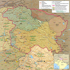
चित्र:Kashmir region 2004.jpg

ए नमूना के साइज: 604 × 599 पिक्सेल. अउरी रिजोल्यूशन: 242 × 240 पिक्सेल | 484 × 480 पिक्सेल | 774 × 768 पिक्सेल | 1,032 × 1,024 पिक्सेल | 1,579 × 1,567 पिक्सेल.
ओरिजनल फाइल (1,579 × 1,567 पिक्सेल, फाइल साइज: 1.71 MB, MIME टाइप: image/jpeg)
| बिबरण |
English: Kashmir Region 2004 |
|||
| तारीख | ||||
| स्रोत | http://www.lib.utexas.edu/maps/middle_east_and_asia/kashmir_region_2004.jpg | |||
| लेखक | CIA | |||
| परमीशन (एह फाइल के दुबारा इस्तेमाल) |
|
|||
| Other versions |
 .jpg)
|


फाइल के इतिहास
ओ समय ई फाइल कइसन लउके ई देखे खातिर कौनों तारीख/समय पर क्लिक करीं।
| तारीख/समय | चिप्पी रूप | डाइमेंशन | प्रयोगकर्ता | टिप्पणी | |
|---|---|---|---|---|---|
| वर्तमान | 21:45, 6 जून 2010 | | 1,579 × 1,567 (1.71 MB) | Ras67 | slightly rotated and cropped |
| 18:46, 7 मार्च 2006 |  | 1,616 × 1,623 (789 KB) | Jungpionier | Kashmir Region 2004 Source URL: [http://www.lib.utexas.edu/maps/middle_east_and_asia/kashmir_region_2004.jpg]. {{PD-USGov-CIA}} |
फाइल के उपयोग
फाइल के इस्तेमाल पन्ना करत बा:
बैस्विक फाइल उपयोग
नीचे दिहल अउरी विकिसभ पर एह फाइल के इस्तेमाल हो रहल बा:
- af.wikipedia.org पर इस्तेमाल
- ang.wikipedia.org पर इस्तेमाल
- ar.wikipedia.org पर इस्तेमाल
- arz.wikipedia.org पर इस्तेमाल
- azb.wikipedia.org पर इस्तेमाल
- az.wikipedia.org पर इस्तेमाल
- be-tarask.wikipedia.org पर इस्तेमाल
- be.wikipedia.org पर इस्तेमाल
- bg.wikipedia.org पर इस्तेमाल
- bn.wikipedia.org पर इस्तेमाल
- br.wikipedia.org पर इस्तेमाल
- ca.wikipedia.org पर इस्तेमाल
- cdo.wikipedia.org पर इस्तेमाल
- ckb.wikipedia.org पर इस्तेमाल
- cs.wikipedia.org पर इस्तेमाल
- da.wikipedia.org पर इस्तेमाल
- de.wikipedia.org पर इस्तेमाल
- de.wikinews.org पर इस्तेमाल
- diq.wikipedia.org पर इस्तेमाल
- el.wikipedia.org पर इस्तेमाल
- en.wikipedia.org पर इस्तेमाल
एह फाइल के अउरी बैस्विक इस्तेमाल देखीं