चित्र:Strait of Dover map.png

ए नमूना के साइज: 798 × 599 पिक्सेल. अउरी रिजोल्यूशन: 320 × 240 पिक्सेल | 639 × 480 पिक्सेल | 1,000 × 751 पिक्सेल.
ओरिजनल फाइल (1,000 × 751 पिक्सेल, फाइल साइज: 187 KB, MIME टाइप: image/png)
सारांश
| बिबरण |
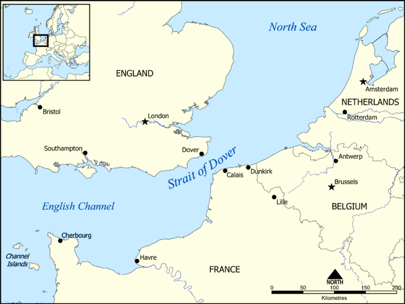
This map shows the location of the Strait of Dover between England and France, and part of the English Channel and the North Sea. It also shows nearby towns such as Dover, Calais, and Dunkirk. Created by NormanEinstein, December 15, 2005. |
| तारीख | १५ दिसंबर २००५ (original upload date) |
| स्रोत | No machine-readable source provided. Own work assumed (based on copyright claims). |
| लेखक | No machine-readable author provided. NormanEinstein assumed (based on copyright claims). |
लाइसेंसिंग
I, the copyright holder of this work, hereby publish it under the following licenses:

|
जीएनयू फ्री डाकुमेंटेशन लाइसेंस, वर्जन 1.2 या फिर कौनो भी बाद के प्रकाशित फ्री साफ्टवेयर फाउंडेशन लाइसेंस के शर्त के तहत, एह डाकुमेंट के नकल करे, बितरण करे आ/भा बदलाव करे के परमीशन दिहल गइल बा; एह में इनवैरिएंट खंड सभ नइखे शामिल, मुखपृष्ट के पाठ नइखे शामिल, आ बैक-कभर के पाठ नइखे शामिल। लाइसेंस के एगो प्रति जीएनयू फ्री डाकुमेंटेशन लाइसेंस नाँव के खंड में दिहल गइल बा। |
| ई फाइल Creative Commons Attribution-Share Alike 3.0 Unported लाइसेंस की तहत लाइसेंसी बा। | ||
| ||
| This licensing tag was added to this file as part of the GFDL licensing update. |
रउआँ अपनी जरूरत के लाइसेंस बीछ सकत बानीं।
Derivative works
-
 hrvatski (SVG)
 -
 македонски (SVG)
 -
 English (PNG), showing evacuation routes of the Dunkirk evacuation


| Annotations | This image is annotated: View the annotations at Commons |
फाइल के इतिहास
ओ समय ई फाइल कइसन लउके ई देखे खातिर कौनों तारीख/समय पर क्लिक करीं।
| तारीख/समय | चिप्पी रूप | डाइमेंशन | प्रयोगकर्ता | टिप्पणी | |
|---|---|---|---|---|---|
| वर्तमान | 19:17, 13 जून 2014 | | 1,000 × 751 (187 KB) | Hohum | Adjust colours |
| 15:34, 15 दिसंबर 2005 |  | 1,000 × 751 (296 KB) | NormanEinstein | This map shows the location of the Strait of Dover between England and France, and part of the English Channel and the North Sea. It also shows nearby towns such as Dover, Calais, and Dunkirk. Created by NormanEinstein, December 15, 2005. {{GFDL-self}} |
फाइल के उपयोग
फाइल के इस्तेमाल पन्ना करत बा:
बैस्विक फाइल उपयोग
नीचे दिहल अउरी विकिसभ पर एह फाइल के इस्तेमाल हो रहल बा:
- af.wikipedia.org पर इस्तेमाल
- an.wikipedia.org पर इस्तेमाल
- ar.wikipedia.org पर इस्तेमाल
- ba.wikipedia.org पर इस्तेमाल
- be-tarask.wikipedia.org पर इस्तेमाल
- be.wikipedia.org पर इस्तेमाल
- bg.wikipedia.org पर इस्तेमाल
- bn.wikipedia.org पर इस्तेमाल
- br.wikipedia.org पर इस्तेमाल
- da.wikipedia.org पर इस्तेमाल
- de.wikipedia.org पर इस्तेमाल
- el.wikipedia.org पर इस्तेमाल
- en.wikipedia.org पर इस्तेमाल
- en.wikibooks.org पर इस्तेमाल
- fa.wikipedia.org पर इस्तेमाल
- fi.wikipedia.org पर इस्तेमाल
- fr.wikipedia.org पर इस्तेमाल
- fy.wikipedia.org पर इस्तेमाल
- gl.wikipedia.org पर इस्तेमाल
- hu.wikipedia.org पर इस्तेमाल
- id.wikipedia.org पर इस्तेमाल
- it.wikipedia.org पर इस्तेमाल
- ja.wikipedia.org पर इस्तेमाल
- la.wikipedia.org पर इस्तेमाल
- mr.wikipedia.org पर इस्तेमाल
- ms.wikipedia.org पर इस्तेमाल
- nn.wikipedia.org पर इस्तेमाल
- no.wikipedia.org पर इस्तेमाल
- pt.wikipedia.org पर इस्तेमाल
- ro.wikipedia.org पर इस्तेमाल
- simple.wikipedia.org पर इस्तेमाल
- sl.wikipedia.org पर इस्तेमाल
एह फाइल के अउरी बैस्विक इस्तेमाल देखीं