चित्र:Tasman Lake - panoramic view from near its outlet.jpg

ए नमूना के साइज: 800 × 343 पिक्सेल. अउरी रिजोल्यूशन: 320 × 137 पिक्सेल | 640 × 274 पिक्सेल | 1,024 × 439 पिक्सेल | 1,280 × 549 पिक्सेल | 2,560 × 1,097 पिक्सेल | 8,772 × 3,759 पिक्सेल.
ओरिजनल फाइल (8,772 × 3,759 पिक्सेल, फाइल साइज: 10.55 MB, MIME टाइप: image/jpeg)
सारांश
| बिबरण |
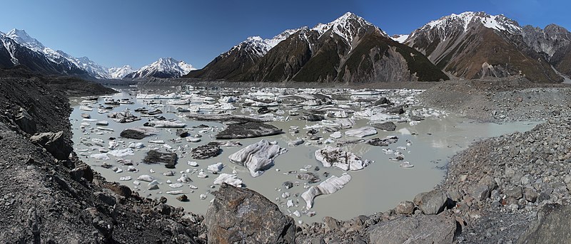
English: Tasman Lake, as seen from near its outlet (far right). Tasman Glacier can be seen across the lake, in the distance on the left. Its lower reaches are mantled with rock debris, as are several of the icebergs in the lake. Two tour boats can be seen in this direction, near a large white iceberg. The glacier's barren lateral and terminal moraines line the rest of the lake's coastline, and the Murchison River has cut an entrance through the lateral moraine opposite this viewpoint. Aoraki / Mount Cook (New Zealand's tallest mountain) is the high peak at far left, and the Minarets are visible in the distance above the glacier. |
| तारीख | |
| स्रोत | आपन रचना |
| लेखक | Avenue |
| Camera location | | View this and other nearby images on: OpenStreetMap |
|---|
| This is a retouched picture, which means that it has been digitally altered from its original version. Modifications: Stiched together from 5 photos; corners filled in.
|

|
NOTE: This image is a panorama consisting of multiple frames that were merged or stitched in software. As a result, this image necessarily underwent some form of digital manipulation. These manipulations may include blending, blurring, cloning, and colour and perspective adjustments. As a result of these adjustments, the image content may be slightly different from reality at the points where multiple images were combined. This manipulation is often required due to lens, perspective, and parallax distortions.
|
लाइसेंसिंग
I, the copyright holder of this work, hereby publish it under the following licenses:
ई फाइल Creative Commons Attribution-Share Alike 3.0 Unported लाइसेंस की तहत लाइसेंसी बा।
- आप फ्री बानी:
- साझा करे खातिर – रचना के नकल करे, बाँटे आ दुसरी जगह भेजे खातिर
- रीमिक्स करे खातिर – काम के अपनी हिसाब से बनावे खातिर
- नीचे दिहल कारणन की तहत:
- एट्रीब्यूशन – लाइसेंस के कड़ी दे के उचित श्रेय (क्रेडिट) दिहल जरूरी बा आ अगर कौनों बदलाव कइल गइल बा तब ओहू के बतावल जाए के चाहीं। आप ई काम कौनों उचित तरीका से क सकत बानी, बाकी ई न झलके के चाहीं की जेकरा लगे लाइसेंस बा ऊ राउर चाहे राउर काम के समर्थन करत बाटे या सही बतावत बा।
- शेयर अलाइक (share alike) – अगर आप एह सामग्री के आधार बना के कुछ रिमिक्स करत बानी, रूप बदलाव करत बानी, चाहे कुछ जोड़ के सामग्री के बढ़ावत बानी, आपके आपन योगदान ठीक एही या कंपेटिबल लाइसेंस जइसन कि ओरिजनल बाटे, के तहत होखे के चाहीं।

|
जीएनयू फ्री डाकुमेंटेशन लाइसेंस, वर्जन 1.2 या फिर कौनो भी बाद के प्रकाशित फ्री साफ्टवेयर फाउंडेशन लाइसेंस के शर्त के तहत, एह डाकुमेंट के नकल करे, बितरण करे आ/भा बदलाव करे के परमीशन दिहल गइल बा; एह में इनवैरिएंट खंड सभ नइखे शामिल, मुखपृष्ट के पाठ नइखे शामिल, आ बैक-कभर के पाठ नइखे शामिल। लाइसेंस के एगो प्रति जीएनयू फ्री डाकुमेंटेशन लाइसेंस नाँव के खंड में दिहल गइल बा। |
रउआँ अपनी जरूरत के लाइसेंस बीछ सकत बानीं।
| Annotations | This image is annotated: View the annotations at Commons |
फाइल के इतिहास
ओ समय ई फाइल कइसन लउके ई देखे खातिर कौनों तारीख/समय पर क्लिक करीं।
| तारीख/समय | चिप्पी रूप | डाइमेंशन | प्रयोगकर्ता | टिप्पणी | |
|---|---|---|---|---|---|
| वर्तमान | 16:07, 22 फरवरी 2011 | | 8,772 × 3,759 (10.55 MB) | Avenue | Fix "hole" along bottom edge. |
| 07:57, 4 नवंबर 2010 |  | 8,772 × 3,759 (10.56 MB) | Avenue | {{Information |Description={{myv|1=Tasman Lake, as seen from near its outlet (far right). Tasman Glacier can be seen across the lake, in the distance on the left. Its lower reaches are mantled with rock debris, as are many of the icebergs in the lake. Two |
फाइल के उपयोग
फाइल के इस्तेमाल पन्ना करत बा:
बैस्विक फाइल उपयोग
नीचे दिहल अउरी विकिसभ पर एह फाइल के इस्तेमाल हो रहल बा:
- bg.wikipedia.org पर इस्तेमाल
- ca.wikipedia.org पर इस्तेमाल
- de.wikipedia.org पर इस्तेमाल
- de.wikivoyage.org पर इस्तेमाल
- en.wikipedia.org पर इस्तेमाल
- fr.wikipedia.org पर इस्तेमाल
- id.wikipedia.org पर इस्तेमाल
- ru.wikipedia.org पर इस्तेमाल