चित्र:United States land claims and cessions 1782-1802.png

ए नमूना के साइज: 573 × 600 पिक्सेल. अउरी रिजोल्यूशन: 229 × 240 पिक्सेल | 458 × 480 पिक्सेल | 747 × 782 पिक्सेल.
ओरिजनल फाइल (747 × 782 पिक्सेल, फाइल साइज: 145 KB, MIME टाइप: image/png)
सारांश
| बिबरण |
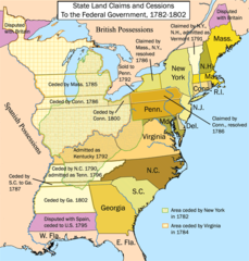
English: This is a map showing state land claims and cessions from 1782-1802 that I made. The disputed territory between New Hampshire and New York formed, in 1777, the independent country of 'New Connecticut' (later renamed 'Vermont') which eventually gained admission as the 14th state in 1791. Boundary disputes between states that were resolved before U.S. independence are not shown. |
| तारीख | १७८२ - १८०२ |
| स्रोत | आपन रचना |
| लेखक | Kmusser |
| Other versions |
|

लाइसेंसिंग
I, the copyright holder of this work, hereby publish it under the following license:
This file is licensed under the Creative Commons Attribution-Share Alike 2.5 Generic license.
- आप फ्री बानी:
- साझा करे खातिर – रचना के नकल करे, बाँटे आ दुसरी जगह भेजे खातिर
- रीमिक्स करे खातिर – काम के अपनी हिसाब से बनावे खातिर
- नीचे दिहल कारणन की तहत:
- एट्रीब्यूशन – लाइसेंस के कड़ी दे के उचित श्रेय (क्रेडिट) दिहल जरूरी बा आ अगर कौनों बदलाव कइल गइल बा तब ओहू के बतावल जाए के चाहीं। आप ई काम कौनों उचित तरीका से क सकत बानी, बाकी ई न झलके के चाहीं की जेकरा लगे लाइसेंस बा ऊ राउर चाहे राउर काम के समर्थन करत बाटे या सही बतावत बा।
- शेयर अलाइक (share alike) – अगर आप एह सामग्री के आधार बना के कुछ रिमिक्स करत बानी, रूप बदलाव करत बानी, चाहे कुछ जोड़ के सामग्री के बढ़ावत बानी, आपके आपन योगदान ठीक एही या कंपेटिबल लाइसेंस जइसन कि ओरिजनल बाटे, के तहत होखे के चाहीं।

|
This historical map image could be re-created using vector graphics as an SVG file. This has several advantages; see Commons:Media for cleanup for more information. If an SVG form of this image is available, please upload it and afterwards replace this template with
{{vector version available|new image name}}.
It is recommended to name the SVG file “United States land claims and cessions 1782-1802.svg”—then the template Vector version available (or Vva) does not need the new image name parameter. |
फाइल के इतिहास
ओ समय ई फाइल कइसन लउके ई देखे खातिर कौनों तारीख/समय पर क्लिक करीं।
| तारीख/समय | चिप्पी रूप | डाइमेंशन | प्रयोगकर्ता | टिप्पणी | |
|---|---|---|---|---|---|
| वर्तमान | 17:12, 16 जनवरी 2012 | | 747 × 782 (145 KB) | Ras67 | cropped |
| 14:26, 28 सितंबर 2006 |  | 765 × 800 (154 KB) | Kmusser | ||
| 14:12, 25 सितंबर 2006 |  | 765 × 800 (154 KB) | Kmusser | ||
| 17:15, 21 सितंबर 2006 |  | 765 × 800 (155 KB) | Kmusser | ||
| 21:46, 20 सितंबर 2006 |  | 765 × 800 (155 KB) | Kmusser | ||
| 21:42, 20 सितंबर 2006 |  | 765 × 800 (495 KB) | Kmusser | This is a map showing state land claims and cessions from 1782-1802 that I made. Boundary disputes between states that were resolved before independence are not shown. |
फाइल के उपयोग
फाइल के इस्तेमाल पन्ना करत बा:
बैस्विक फाइल उपयोग
नीचे दिहल अउरी विकिसभ पर एह फाइल के इस्तेमाल हो रहल बा:
- ar.wikipedia.org पर इस्तेमाल
- az.wikipedia.org पर इस्तेमाल
- bn.wikipedia.org पर इस्तेमाल
- ca.wikipedia.org पर इस्तेमाल
- de.wikipedia.org पर इस्तेमाल
- en.wikipedia.org पर इस्तेमाल
- History of the United States
- Midwestern United States
- Treaty of Paris (1783)
- Northwest Territory
- U.S. territorial sovereignty
- Ohio Country
- Historical regions of the United States
- State cessions
- User:Kmusser/Images
- History of Michigan
- Portal:Michigan
- User:Notuncurious/Working/tmp3
- Confederation period
- User:Notuncurious/Working/tmp6
- Talk:List of capitals in the United States/Archive 1
- User:Drdpw/sandbox2
- User:AkeAcres87/sandbox
- es.wikipedia.org पर इस्तेमाल
- fa.wikipedia.org पर इस्तेमाल
- fr.wikipedia.org पर इस्तेमाल
- he.wikipedia.org पर इस्तेमाल
- hi.wikipedia.org पर इस्तेमाल
- it.wikipedia.org पर इस्तेमाल
- ja.wikipedia.org पर इस्तेमाल
- ko.wikipedia.org पर इस्तेमाल
- ms.wikipedia.org पर इस्तेमाल
- nl.wikipedia.org पर इस्तेमाल
- no.wikipedia.org पर इस्तेमाल
- pt.wikipedia.org पर इस्तेमाल
- ru.wikipedia.org पर इस्तेमाल
एह फाइल के अउरी बैस्विक इस्तेमाल देखीं