चित्र:Yangtze River Map.png
ए से उच्च गुणवत्ता उपलब्ध नइखे।
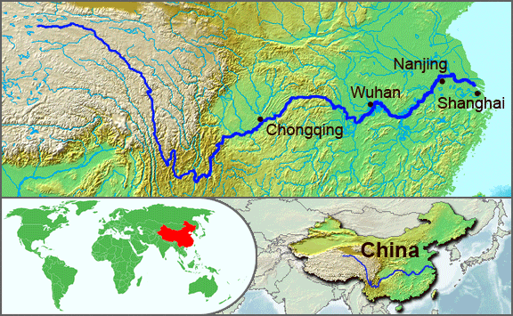
Yangtze_River_Map.png (576 × 355 पिक्सेल, फाइल साइज: 123 KB, MIME टाइप: image/png)
सारांश
| बिबरण |
English: The underlying topographic maps used in this image come from the Demis Web Map Server, and are in the public domain. The world locator map is derived from :Image:BlankMap-World.png. I added the feature layers myself. —Papayoung ☯ 20:57, 1 October 2005 (UTC) |
| तारीख | १ अक्टूबर २००५ (original upload date) |
| स्रोत | Transferred from en.wikipedia to Commons by Common Good using CommonsHelper. |
| लेखक | The original uploader was Papayoung at अंगरेजी विकिपीडिया. |
| Other versions |
|
.JPG)
लाइसेंसिंग
| ई फाइल Creative Commons Attribution-Share Alike 3.0 Unported लाइसेंस की तहत लाइसेंसी बा। Subject to disclaimers. | ||
| ||
| This licensing tag was added to this file as part of the GFDL licensing update. |

|
जीएनयू फ्री डाकुमेंटेशन लाइसेंस, वर्जन 1.2 या फिर कौनो भी बाद के प्रकाशित फ्री साफ्टवेयर फाउंडेशन लाइसेंस के शर्त के तहत, एह डाकुमेंट के नकल करे, बितरण करे आ/भा बदलाव करे के परमीशन दिहल गइल बा; एह में इनवैरिएंट खंड सभ नइखे शामिल, मुखपृष्ट के पाठ नइखे शामिल, आ बैक-कभर के पाठ नइखे शामिल। लाइसेंस के एगो प्रति जीएनयू फ्री डाकुमेंटेशन लाइसेंस नाँव के खंड में दिहल गइल बा। Subject to disclaimers. |
Original upload log
The original description page was here. All following user names refer to en.wikipedia.
- 2005-10-01 20:51 Papayoung 576×355× (125604 bytes) The underlying topographic maps used in this image come from the [http://www2.demis.nl/mapserver/mapper.asp Demis Web Map Server], and are in the public domain. The world locator map is derived from [[Commons:Image:BlankMap-World.png|BlankMap-World.png]].
- 2005-09-25 22:57 Papayoung 936×363× (221574 bytes) The underlying topographic maps used in this image come from the [http://www2.demis.nl/mapserver/mapper.asp Demis Web Map Server], and are in the public domain. I added the feature layers myself. —~~~~
फाइल के इतिहास
ओ समय ई फाइल कइसन लउके ई देखे खातिर कौनों तारीख/समय पर क्लिक करीं।
| तारीख/समय | चिप्पी रूप | डाइमेंशन | प्रयोगकर्ता | टिप्पणी | |
|---|---|---|---|---|---|
| वर्तमान | 20:30, 7 मई 2009 | | 576 × 355 (123 KB) | File Upload Bot (Magnus Manske) | {{BotMoveToCommons|en.wikipedia|year={{subst:CURRENTYEAR}}|month={{subst:CURRENTMONTHNAME}}|day={{subst:CURRENTDAY}}}} {{Information |Description={{en|The underlying topographic maps used in this image come from the [http://www2.demis.nl/mapserver/mapper |
फाइल के उपयोग
फाइल के इस्तेमाल पन्ना करत बा:
बैस्विक फाइल उपयोग
नीचे दिहल अउरी विकिसभ पर एह फाइल के इस्तेमाल हो रहल बा:
- af.wikipedia.org पर इस्तेमाल
- als.wikipedia.org पर इस्तेमाल
- am.wikipedia.org पर इस्तेमाल
- ary.wikipedia.org पर इस्तेमाल
- ast.wikipedia.org पर इस्तेमाल
- as.wikipedia.org पर इस्तेमाल
- azb.wikipedia.org पर इस्तेमाल
- be-tarask.wikipedia.org पर इस्तेमाल
- bn.wikipedia.org पर इस्तेमाल
- bo.wikipedia.org पर इस्तेमाल
- br.wikipedia.org पर इस्तेमाल
- cs.wikipedia.org पर इस्तेमाल
- de.wikipedia.org पर इस्तेमाल
- en.wikipedia.org पर इस्तेमाल
- en.wikinews.org पर इस्तेमाल
- es.wikipedia.org पर इस्तेमाल
- et.wikipedia.org पर इस्तेमाल
- eu.wikipedia.org पर इस्तेमाल
- fi.wikipedia.org पर इस्तेमाल
- fo.wikipedia.org पर इस्तेमाल
- frr.wikipedia.org पर इस्तेमाल
- fr.wikipedia.org पर इस्तेमाल
- fr.wikivoyage.org पर इस्तेमाल
- fr.wiktionary.org पर इस्तेमाल
- fy.wikipedia.org पर इस्तेमाल
- hi.wikipedia.org पर इस्तेमाल
- hu.wikipedia.org पर इस्तेमाल
- hy.wikipedia.org पर इस्तेमाल
- hyw.wikipedia.org पर इस्तेमाल
- id.wikipedia.org पर इस्तेमाल
- ilo.wikipedia.org पर इस्तेमाल
- incubator.wikimedia.org पर इस्तेमाल
- io.wikipedia.org पर इस्तेमाल
- it.wikipedia.org पर इस्तेमाल
- ja.wikipedia.org पर इस्तेमाल
- ka.wikipedia.org पर इस्तेमाल
- ko.wikipedia.org पर इस्तेमाल
- ku.wikipedia.org पर इस्तेमाल
- la.wikipedia.org पर इस्तेमाल
- lfn.wikipedia.org पर इस्तेमाल
- lt.wikipedia.org पर इस्तेमाल
एह फाइल के अउरी बैस्विक इस्तेमाल देखीं