चित्र:Yellowrivermap.jpg
ए नमूना के साइज: 800 × 503 पिक्सेल. अउरी रिजोल्यूशन: 320 × 201 पिक्सेल | 640 × 403 पिक्सेल | 1,024 × 644 पिक्सेल | 1,280 × 805 पिक्सेल | 2,497 × 1,571 पिक्सेल.
ओरिजनल फाइल (2,497 × 1,571 पिक्सेल, फाइल साइज: 1.19 MB, MIME टाइप: image/jpeg)
सारांश
| बिबरण |
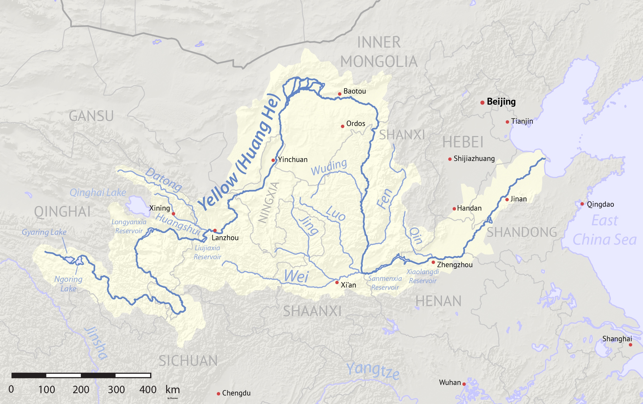
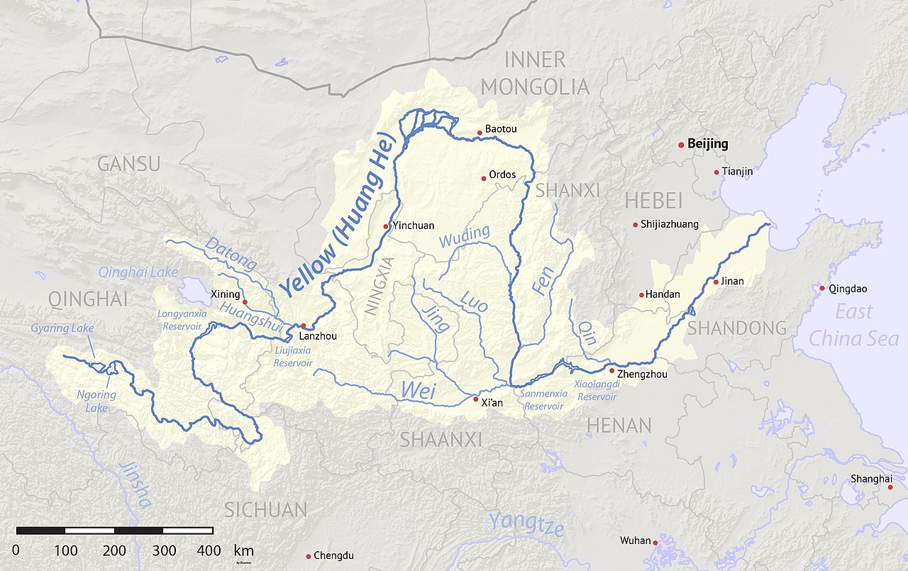
English: Map of the Yellow River, whose watershed covers most of northern China and drains to the Yellow Sea |
| तारीख | (2017-08-10 revised) |
| स्रोत | Created using Natural Earth and NASA SRTM data, both public domain. |
| लेखक | Shannon1 |
| Other versions |
Derivative works of this file: |
लाइसेंसिंग
I, the copyright holder of this work, hereby publish it under the following licenses:

|
जीएनयू फ्री डाकुमेंटेशन लाइसेंस, वर्जन 1.2 या फिर कौनो भी बाद के प्रकाशित फ्री साफ्टवेयर फाउंडेशन लाइसेंस के शर्त के तहत, एह डाकुमेंट के नकल करे, बितरण करे आ/भा बदलाव करे के परमीशन दिहल गइल बा; एह में इनवैरिएंट खंड सभ नइखे शामिल, मुखपृष्ट के पाठ नइखे शामिल, आ बैक-कभर के पाठ नइखे शामिल। लाइसेंस के एगो प्रति जीएनयू फ्री डाकुमेंटेशन लाइसेंस नाँव के खंड में दिहल गइल बा। |
This file is licensed under the Creative Commons Attribution-Share Alike 4.0 International, 3.0 Unported, 2.5 Generic, 2.0 Generic and 1.0 Generic license.
- आप फ्री बानी:
- साझा करे खातिर – रचना के नकल करे, बाँटे आ दुसरी जगह भेजे खातिर
- रीमिक्स करे खातिर – काम के अपनी हिसाब से बनावे खातिर
- नीचे दिहल कारणन की तहत:
- एट्रीब्यूशन – लाइसेंस के कड़ी दे के उचित श्रेय (क्रेडिट) दिहल जरूरी बा आ अगर कौनों बदलाव कइल गइल बा तब ओहू के बतावल जाए के चाहीं। आप ई काम कौनों उचित तरीका से क सकत बानी, बाकी ई न झलके के चाहीं की जेकरा लगे लाइसेंस बा ऊ राउर चाहे राउर काम के समर्थन करत बाटे या सही बतावत बा।
- शेयर अलाइक (share alike) – अगर आप एह सामग्री के आधार बना के कुछ रिमिक्स करत बानी, रूप बदलाव करत बानी, चाहे कुछ जोड़ के सामग्री के बढ़ावत बानी, आपके आपन योगदान ठीक एही या कंपेटिबल लाइसेंस जइसन कि ओरिजनल बाटे, के तहत होखे के चाहीं।
रउआँ अपनी जरूरत के लाइसेंस बीछ सकत बानीं।
फाइल के इतिहास
ओ समय ई फाइल कइसन लउके ई देखे खातिर कौनों तारीख/समय पर क्लिक करीं।
| तारीख/समय | चिप्पी रूप | डाइमेंशन | प्रयोगकर्ता | टिप्पणी | |
|---|---|---|---|---|---|
| वर्तमान | 04:17, 11 अगस्त 2017 | | 2,497 × 1,571 (1.19 MB) | Shannon1 | Uploaded clearer version with corrected data. |
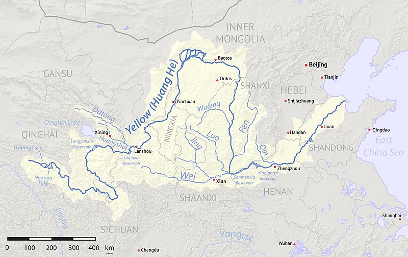
| 02:23, 2 मार्च 2010 |  | 1,100 × 544 (401 KB) | Shannon1 | {{Information |Description={{en|1=Map of the Yellow River, whose watershed covers most of northern China and drains to the Bohai Sea}} |Source=Background and river course data from http://www2.demis.nl/mapserver/mapper.asp |Author=[[User:Shannonchan|Shan |
फाइल के उपयोग
फाइल के इस्तेमाल पन्ना करत बा:
बैस्विक फाइल उपयोग
नीचे दिहल अउरी विकिसभ पर एह फाइल के इस्तेमाल हो रहल बा:
- af.wikipedia.org पर इस्तेमाल
- als.wikipedia.org पर इस्तेमाल
- an.wikipedia.org पर इस्तेमाल
- ary.wikipedia.org पर इस्तेमाल
- ast.wikipedia.org पर इस्तेमाल
- as.wikipedia.org पर इस्तेमाल
- azb.wikipedia.org पर इस्तेमाल
- ba.wikipedia.org पर इस्तेमाल
- bcl.wikipedia.org पर इस्तेमाल
- be-tarask.wikipedia.org पर इस्तेमाल
- bg.wikipedia.org पर इस्तेमाल
- bn.wikipedia.org पर इस्तेमाल
- bo.wikipedia.org पर इस्तेमाल
- br.wikipedia.org पर इस्तेमाल
- bs.wikipedia.org पर इस्तेमाल
- bxr.wikipedia.org पर इस्तेमाल
- ca.wikipedia.org पर इस्तेमाल
- ceb.wikipedia.org पर इस्तेमाल
- cs.wikipedia.org पर इस्तेमाल
- de.wikipedia.org पर इस्तेमाल
- diq.wikipedia.org पर इस्तेमाल
- en.wikipedia.org पर इस्तेमाल
- en.wikivoyage.org पर इस्तेमाल
- eo.wikipedia.org पर इस्तेमाल
- es.wikipedia.org पर इस्तेमाल
एह फाइल के अउरी बैस्विक इस्तेमाल देखीं