चित्र:Political map of Canada.svg

Size of this PNG preview of this SVG file: 736 × 599 पिक्सेल. अउरी रिजोल्यूशन: 295 × 240 पिक्सेल | 590 × 480 पिक्सेल | 943 × 768 पिक्सेल | 1,258 × 1,024 पिक्सेल | 2,516 × 2,048 पिक्सेल | 1,130 × 920 पिक्सेल.
ओरिजनल फाइल (एसवीजी फाइल, नॉमिनली 1,130 x 920 पिक्सल, फाइल के आकार: 272 KB)
सारांश
| बिबरण |
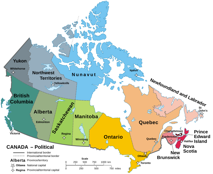
English: A map of Canada in its Provinces and territories Català: Mapa de les províncies i territoris del Canadà. |
||
| तारीख | |||
| स्रोत | Localisation Manitoba.svg | ||
| लेखक | Hogweard | ||
| परमीशन (एह फाइल के दुबारा इस्तेमाल) |
|
||
| Other versions |
Carte Politique du Canada.svg File:Political map of Canada.svg has 1 translations.
|

फाइल के इतिहास
ओ समय ई फाइल कइसन लउके ई देखे खातिर कौनों तारीख/समय पर क्लिक करीं।
| तारीख/समय | चिप्पी रूप | डाइमेंशन | प्रयोगकर्ता | टिप्पणी | |
|---|---|---|---|---|---|
| वर्तमान | 11:58, 22 सितंबर 2023 | | 1,130 × 920 (272 KB) | Lalpino | File uploaded using svgtranslate tool (https://svgtranslate.toolforge.org/). Added translation for ca. |
| 14:58, 14 अक्टूबर 2022 |  | 1,130 × 920 (256 KB) | Enkhsaihan2005 | File uploaded using svgtranslate tool (https://svgtranslate.toolforge.org/). Added translation for mn. | |
| 00:43, 21 जून 2022 |  | 1,130 × 920 (211 KB) | -tynjee | File uploaded using svgtranslate tool (https://svgtranslate.toolforge.org/). Added translation for vi. | |
| 02:21, 23 अगस्त 2021 |  | 1,130 × 920 (199 KB) | Praça de Maio | File uploaded using svgtranslate tool (https://svgtranslate.toolforge.org/). Added translation for tr. | |
| 01:59, 29 जनवरी 2021 |  | 1,130 × 920 (161 KB) | Allice Hunter | Reverted to version as of 11:37, 19 October 2020 (UTC) | |
| 01:59, 29 जनवरी 2021 |  | 512 × 424 (95 KB) | Allice Hunter | Largest cities | |
| 11:37, 19 अक्टूबर 2020 |  | 1,130 × 920 (161 KB) | Hogweard | Fixed N&L label | |
| 08:48, 18 अक्टूबर 2020 |  | 1,130 × 920 (161 KB) | Hogweard | {{Information |description=A map of Canada in its Provinces and territories |date=2020-10-18 |source={{f|Localisation_Manitoba.svg}} |author={{u|Hogweard}} |permission={{PD-self}} |other versions={{f|Carte Politique du Canada.svg}} }} Category:SVG maps of Canada Category:English language maps of Canada Category:Political maps of Canada |
फाइल के उपयोग
फाइल के इस्तेमाल पन्ना करत बा:
बैस्विक फाइल उपयोग
नीचे दिहल अउरी विकिसभ पर एह फाइल के इस्तेमाल हो रहल बा:
- as.wikipedia.org पर इस्तेमाल
- azb.wikipedia.org पर इस्तेमाल
- br.wikipedia.org पर इस्तेमाल
- ca.wikipedia.org पर इस्तेमाल
- el.wikipedia.org पर इस्तेमाल
- en.wikipedia.org पर इस्तेमाल
- io.wikipedia.org पर इस्तेमाल
- ku.wikipedia.org पर इस्तेमाल
- mdf.wikipedia.org पर इस्तेमाल
- mn.wikipedia.org पर इस्तेमाल
- my.wikipedia.org पर इस्तेमाल
- pa.wikipedia.org पर इस्तेमाल
- sq.wikipedia.org पर इस्तेमाल
- sr.wikipedia.org पर इस्तेमाल
- tl.wikipedia.org पर इस्तेमाल
- to.wikipedia.org पर इस्तेमाल
- tr.wikipedia.org पर इस्तेमाल
- uk.wikipedia.org पर इस्तेमाल
- vi.wikipedia.org पर इस्तेमाल