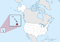
हवाई
निर्देशांक: 21°18′41″N 157°47′47″W / 21.31139°N 157.79639°W
हवाई संयुक्त राज्य अमेरिका का एक राज्य बा|
| State of Hawaii Mokuʻāina o Hawaiʻi (Hawaiian) | |
|---|---|
 | |
| ऑफिशियल भाषा | English, Hawaiian |
| लोग कहाला | Hawaiian[नोट 1] |
| राजधानी (आ सभसे बड़ शहर) | Honolulu |
| सभसे बड़ मेट्रो | Island of Oʻahu |
| रकबा | रैंक 43वाँ |
| • कुल | 10,931 sq मील (28,311 किमी2) |
| • % जलक्षेत्र | 41.2 |
| • अक्षांस | 18° 55′ N to 28° 27′ N |
| • देशांतर | 154° 48′ W to 178° 22′ W |
| जनसंख्या | रैंक 40th |
| • कुल | 1,427,538 (2017 est.)[1] |
| • घनत्व | 221/बर्ग मील (82.6/किमी2) रैंक 13th |
| ऊँचाई | |
| • सभसे ऊँच जगह | Mauna Kea[3][4][5][6] 13,796 फीट (4205.0 मीटर) |
| • औसत | 3,030 फीट (920 मीटर) |
| • सभसे निचाई के जगह | Pacific Ocean[4] समुंद्र तल |
| राज्य के दर्जा से पहिले | Territory of Hawaii |
| संघ में शामिल भइल | August 21, 1959 (50वाँ) |
| टाइम जोन | Hawaii: UTC −10 (no DST) |
| छोट नाँव | HI, H.I. |
| वेबसाइट | www |
| ई अमेरिका (यूएसए) के जगह संबंधी लेख एगो आधार बाटे। जानकारी जोड़ के एकरा के बढ़ावे में विकिपीडिया के मदद करीं। |
उद्धरण खराबी:<ref> tags exist for a group named "नोट", but no corresponding <references group="नोट"/> tag was found
- ↑ "Hawaii: Population estimates". U.S. Census Bureau. जुलाई 1, 2017. Retrieved मई 6, 2017.
- ↑ "Median Annual Household Income". The Henry J. Kaiser Family Foundation. Retrieved दिसंबर 9, 2016.
- ↑ "Summit USGS 1977". NGS data sheet. U.S. National Geodetic Survey. Retrieved अक्टूबर 20, 2011.
- ↑ 4.0 4.1 "Elevations and Distances in the United States". United States Geological Survey. 2001. Archived from the original on अक्टूबर 15, 2011. Retrieved अक्टूबर 21, 2011.
- ↑ Elevation adjusted to North American Vertical Datum of 1988.
- ↑ The summit of Mauna Kea is the highest point in Oceania. Mauna Kea is also the tallest mountain on Earth when measured from base to summit. The shield volcano sits on the floor of the Pacific Ocean at a depth of 5,998 मीटर (19,678 फीट) for a total height of 10,205.3 मीटर (33,482 फीट)