चित्र:Okraoutput.png
ए नमूना के साइज: 800 × 480 पिक्सेल. अउरी रिजोल्यूशन: 320 × 192 पिक्सेल | 1,024 × 614 पिक्सेल | 1,600 × 960 पिक्सेल.
ओरिजनल फाइल (1,600 × 960 पिक्सेल, फाइल साइज: 430 KB, MIME टाइप: image/png)
सारांश
| बिबरण |
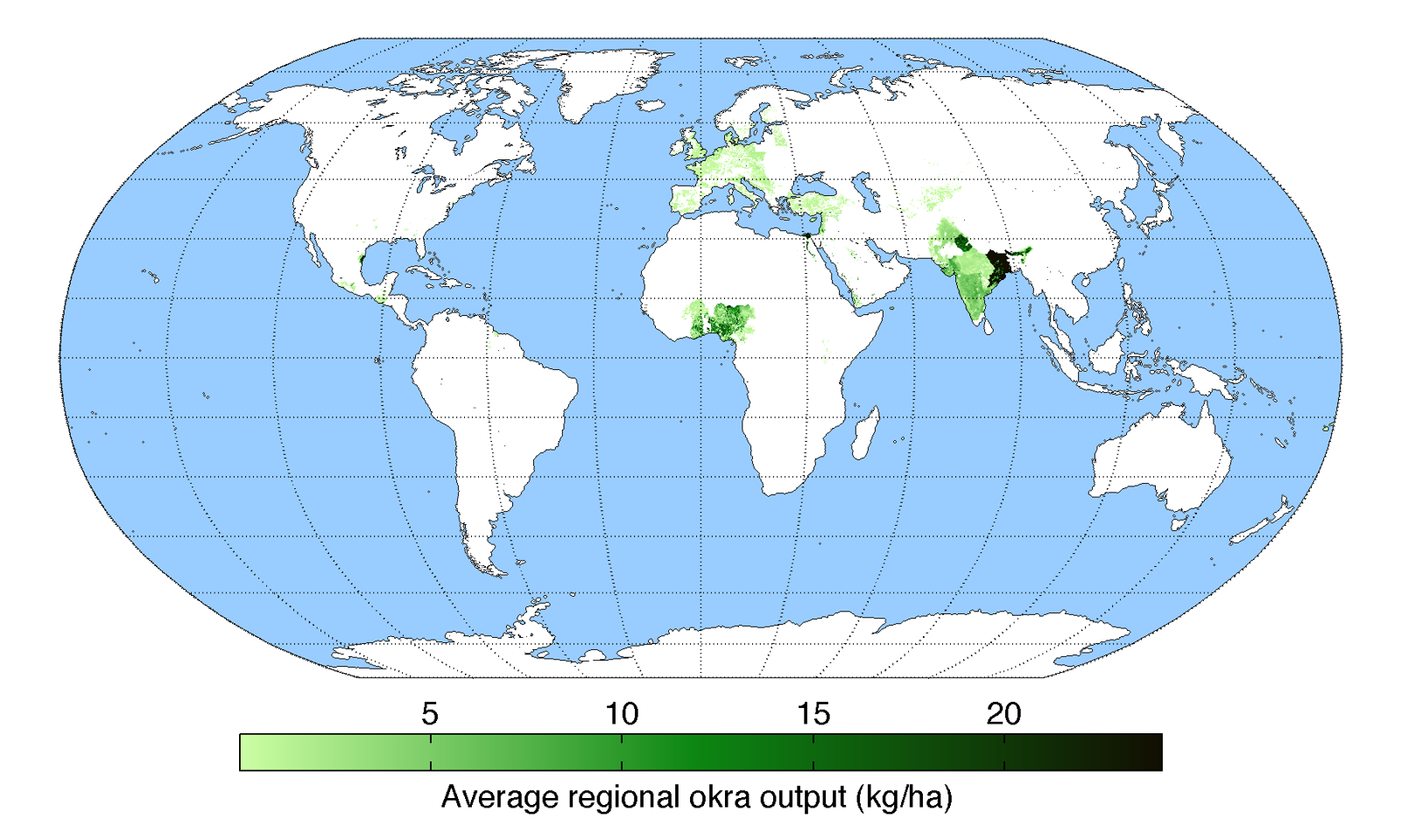
English: Map of okra production (average percentage of land used for its production times average yield in each grid cell) across the world compiled by the University of Minnesota Institute on the Environment with data from: Monfreda, C., N. Ramankutty, and J.A. Foley. 2008. Farming the planet: 2. Geographic distribution of crop areas, yields, physiological types, and net primary production in the year 2000. Global Biogeochemical Cycles 22: GB1022 |
| तारीख | |
| स्रोत | आपन रचना |
| लेखक | AndrewMT |
लाइसेंसिंग
I, the copyright holder of this work, hereby publish it under the following license:
This file is licensed under the Creative Commons Attribution 3.0 Unported license.
- आप फ्री बानी:
- साझा करे खातिर – रचना के नकल करे, बाँटे आ दुसरी जगह भेजे खातिर
- रीमिक्स करे खातिर – काम के अपनी हिसाब से बनावे खातिर
- नीचे दिहल कारणन की तहत:
- एट्रीब्यूशन – लाइसेंस के कड़ी दे के उचित श्रेय (क्रेडिट) दिहल जरूरी बा आ अगर कौनों बदलाव कइल गइल बा तब ओहू के बतावल जाए के चाहीं। आप ई काम कौनों उचित तरीका से क सकत बानी, बाकी ई न झलके के चाहीं की जेकरा लगे लाइसेंस बा ऊ राउर चाहे राउर काम के समर्थन करत बाटे या सही बतावत बा।
फाइल के इतिहास
ओ समय ई फाइल कइसन लउके ई देखे खातिर कौनों तारीख/समय पर क्लिक करीं।
| तारीख/समय | चिप्पी रूप | डाइमेंशन | प्रयोगकर्ता | टिप्पणी | |
|---|---|---|---|---|---|
| वर्तमान | 20:30, 19 मई 2010 | | 1,600 × 960 (430 KB) | AndrewMT | {{Information |Description={{en|1=Map of okra production across the world compiled by the University of Minnesota Institute on the Environment with data from: Monfreda, C., N. Ramankutty, and J.A. Foley. 2008. Farming the planet: 2. Geographic distributio |
फाइल के उपयोग
फाइल के इस्तेमाल पन्ना करत बा:
बैस्विक फाइल उपयोग
नीचे दिहल अउरी विकिसभ पर एह फाइल के इस्तेमाल हो रहल बा:
- ar.wikipedia.org पर इस्तेमाल
- arz.wikipedia.org पर इस्तेमाल
- ast.wikipedia.org पर इस्तेमाल
- bcl.wikipedia.org पर इस्तेमाल
- bg.wikipedia.org पर इस्तेमाल
- ca.wikipedia.org पर इस्तेमाल
- cs.wikipedia.org पर इस्तेमाल
- da.wikipedia.org पर इस्तेमाल
- en.wiktionary.org पर इस्तेमाल
- eu.wikipedia.org पर इस्तेमाल
- gl.wikipedia.org पर इस्तेमाल
- ha.wikipedia.org पर इस्तेमाल
- he.wikipedia.org पर इस्तेमाल
- hu.wikipedia.org पर इस्तेमाल
- hy.wikipedia.org पर इस्तेमाल
- ilo.wikipedia.org पर इस्तेमाल
- is.wikipedia.org पर इस्तेमाल
- ja.wikipedia.org पर इस्तेमाल
- kn.wikipedia.org पर इस्तेमाल
- mnw.wiktionary.org पर इस्तेमाल
- nn.wikipedia.org पर इस्तेमाल
- or.wikipedia.org पर इस्तेमाल
- pa.wikipedia.org पर इस्तेमाल
- pnb.wikipedia.org पर इस्तेमाल
- pt.wikipedia.org पर इस्तेमाल
- sd.wikipedia.org पर इस्तेमाल
- simple.wikipedia.org पर इस्तेमाल
- sl.wikipedia.org पर इस्तेमाल
- sr.wikipedia.org पर इस्तेमाल
- sv.wikipedia.org पर इस्तेमाल
- th.wikipedia.org पर इस्तेमाल
- tr.wikipedia.org पर इस्तेमाल
- ur.wikipedia.org पर इस्तेमाल
- www.wikidata.org पर इस्तेमाल
- zh-yue.wikipedia.org पर इस्तेमाल
- zh.wikipedia.org पर इस्तेमाल