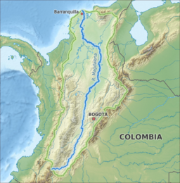
मैग्डलीन नदी
मैग्डलीन नदी (अंग्रेजी: Magdalena River) दक्खिन अमेरिका महादीप के एक ठो प्रमुख नदी बाटे।
| Magdalena | |
| River | |
The delta of the Magdalena River
| |
| नाँवउत्पत्ती: Biblical figure Mary Magdalene | |
| देस | Colombia |
|---|---|
| सहायिका | |
| - बायें से | Páez River, Saldaña River, La Miel River, Nare River, Cauca River, San Jorge River |
| - दहिने से | Cabrera River, Bogotá River, Negro River, Carare River, Sogamoso River, Cesar River |
| शहर | Neiva, Girardot, Honda, La Dorada, Puerto Boyacá, Puerto Berrío, Barrancabermeja, Santa Cruz de Mompox, Magangué, Barranquilla |
| उदगम | La Magdalena lagoon [1] |
| - लोकेशन | Colombian Massif, Colombia |
| - ऊँचाई | 3,685 मी (12,090 फीट) |
| - निर्देशांक | 1°56′3″N 76°36′29″W / 1.93417°N 76.60806°W |
| मुहाना | Caribbean Sea |
| - लोकेशन | Barranquilla, Colombia |
| - ऊँचाई | 0 मी (0 फीट) |
| - निर्देशांक | 11°7′0″N 74°51′0″W / 11.11667°N 74.85000°Wनिर्देशांक: 11°7′0″N 74°51′0″W / 11.11667°N 74.85000°W |
| लंबाई | 1,528 किमी (949 मील) [2] |
| थाला | 257,438 किमी2 (99,397 वर्ग मील) |
| जलनिकास | for Calamar, Bolívar |
| - औसत | 7,200 m3/s (254,300 cu ft/s) [3] |
| - अधिकतम | 12,000 m3/s (423,800 cu ft/s) |
| - सबसे कम | 2,000 m3/s (70,600 cu ft/s) |
| Protection status | |
| ऑफिशियल नाँव | Sistema Delta Estuarino del Río Magdalena, Ciénaga Grande de Santa Marta |
| तिथी | 18 June 1998 |
| रिफरेंस नं॰ | 951[4] |
Map of the Magdalena River watershed
| |
संदर्भ
संपादन करीं- ↑ Restrepo, J.; Kjerfve, B.; Hermelin, M.; Restrepo, J. (2006). "Factors controlling sediment yield in a major South American drainage basin: The Magdalena River, Colombia". Journal of Hydrology. 316: 213–232. doi:10.1016/j.jhydrol.2005.05.002.
- ↑ "Sistema de informacion Ambiental de Colombia – SIAC" (Spanish में). Archived from the original on 2018-12-25. Retrieved 2011-07-13.
- ↑ "Chapter 14" (PDF). The Pacific and Caribbean Rivers of Colombia: Water Discharge, Sediment Transport and Dissolved Loads. Archived from the original (PDF) on 2012-03-25. Retrieved 2011-07-13.
- ↑ "Sistema Delta Estuarino del Río Magdalena, Ciénaga Grande de Santa Marta". Ramsar Sites Information Service. Retrieved 25 April 2018.
| ई लेख कौनो नदी के बारे में एगो आधार बाटे। जानकारी जोड़ के एकरा के बढ़ावे में विकिपीडिया के मदद करीं। |

